
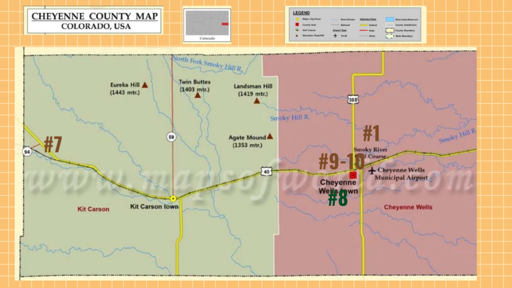
Point 1
OLD WELLS CAVE BY ROSE GALLI
A natural conglomerate of rock caves can be found on the south bluffs of the Smoky Hill River five miles north of present-day Cheyenne Wells. Coming from the south on Highway 385 from Cheyenne Wells the caves are unnoticeable. If you walk to the edge of the bluff from the south where the grassy turf ceases and stand on the firm rock it is there that the old caves are exposed.
By 1826 nomad Indians: The Cheyenne Arapahoe, and Kiowa lived in this area, hunting buffalo, and living in teepees. The Smoky Hill River was a beautiful place to camp with its natural water feed springs and big cottonwood trees. The bluffs provided a natural shelter for them.
It is believed that the Cheyenne Indians first discovered the caves. By digging they extended the largest cave to 30 feet inward and was tall enough for a man to stand upright in.
By 1860 the largest cave became known as Buffalo Bills cave as it was reported that he had spent the night here. Before that this place was known as “Indian Wells” as the Indians had dug shallow wells here.
By 1860 the Government took over this area. Later came the stagecoach and immigrant trails, that past through and spent the night.
Close to the cave was a fort in which the government kept guards of thirty men, to guard the station and to keep a sharp lookout for Indians. From the cave to the fort was an underground passage. About twenty feet from the cave was a well. A ditch had been dug from the cave to the well so that they could get water without being exposed.
Later, in 1870, when the Union Pacific Railroad was built, and the stage line abolished, the cave and fort were excavated and has since gone to ruin.
Today, you can still find artifacts from these first Cheyenne County residents left behind. Today the cave’s by the river is known as the Old Wells Cave.
Point 2
MILITARY TRAIL BY LETA SMALLEY
The stage line from Fort Wallace, Kansas or Pond Creek, through Sharon Springs, Kansas or Willow Springs, had been laid out by a military captain who progressed westward form Willow Creek to Old Cheyenne Wells, originally known as Indian Wells, then almost due south to Fort Lyon, Colorado. It is said that no surveyors were used to locate this trail, but that a Calvary captain who was familiar with the country lying between Fort Wallace and Fort Lyon would ride ahead of his cavalry regiment several miles and then signal the regiment to travel to his signal point. Then halting them, he would go on several miles again to some high point that was visible to his regiment, and they would again move to the new location. The supply train and freighters followed up the regiment, that in one trip from Fort Wallace to Fort Lyon a trail was easily identified by the perfect tracks of so many traveling on the trail. The trail began known as the Old Military Trail, which connected Fort Wallace on the Smoky Hill River with Fort Lyon on the Arkansas River.
Point 3
The Smoky Hill Trail By Louise Konecne
The Smoky Hill Trail was established in 1859 as a route across Kansas to Colorado during the Pikes Peak Gold Rush. The trail ran from Atchison, Kansas, on the Missouri River to Denver, Colorado. The Smoky Hill Trail, which followed an ancient Indian trail along the Smoky Hill River, was blazed and became the fastest path to the goldfields.
Though the Smoky Hill Trail was far harder and more dangerous than the other prairie trails from the Missouri River to the Rockies, pioneers ignored the possibility of Indian attacks and the scarcity of water to reach the Rocky Mountains.
Thousands of prospectors, homesteaders, and soldiers traveled the trail between 1859 and 1865, many in covered wagons and some on foot, pushing carts and wheelbarrows. Though many survived the trip, often nearly starved, others died at the hands of hostile Indians, thirst, starvation, and the chilling cold once that neared the mountains.
Near Old Cheyenne Wells the Trail was divided into the North Smoky and South Smoky, taking two different paths, ending in Denver. There was another 22 mile path called the “Middle Smoky Hill,” which would later become known as “Starvation Trail” due to the lack of food and water along the way. North would cut about 20 miles of travel to Denver. South trail was also called The Butterfield Trail.
Beginning in 1865, the trail was the route for the short-lived Butterfield Overland Dispatch serving freight and passengers. To protect travelers, the United States Army established several forts along the trail, including Fort Downer, Fort Harker, Fort Hays, Fort Monument, and Fort Wallace. In 1867, the Comanche and the Kiowa, and in 1868, the Sioux and the Arapaho signed treaties withdrawing their opposition to the construction of a railroad along the Smoky Hill River. The Kansas Pacific completed in 1870, rendering the Smoky Hill Trail obsolete.
Point 4
Omaha Trail By Rosemary Lengel
According to the Cheyenne County History Book, this trail entered the east boundary at S19, T12S,
R41W. According to the map the trial intersected with the Smoky Hill Trail. Upon further research,
there is no mention of the Omaha Trail in Kansas or Colorado, except for this one mention in the
Cheyenne County History Book. Since many cattle trails were not named or were not drawn on a map, we can only surmise that this was the case with the Omaha Trail.
Point 5
Texas-Montana Cattle Trail By Rosemary Lengel
The Texas-Montana Cattle Trail became famous as a cattle trail during the Civil War when cattle could not be shipped east from the panhandle of Texas. Cattle prices were falling in Texas and the cattlemen knew they could get a better price per head in Chicago. The problem was, how to get approximately 10,000 to 15,000 head of cattle to Chicago. Since the cattle were too numerous for the amount of pasture that was available, a lice and pestilence infestation, the cattlemen decided to drive the herds north to ample pastureland before continuing on to Chicago. The Cowboy moved the cattle along the trail known as the Texas-Montana Cattle Trail between 1886-1897. The trail passes through Lamar Colorado and Kit Carson Colorado. At the Big Springs station, located on the NE ¼ of Section 12-13-49 in Cheyenne County, which is on the east side of Big Springs Creek where the creek curves around a hill. The cattle rested and were watered thoroughly at The Big Springs Station before being driving on into Montana to fatten and then on to Chicago to be sold and processed.
Point 6
Important Stage Stations in Cheyenne County By Rosemary Lengel
As the need for Stage Stations due to increased traffic along the Smoky Hill Trail, the Stage Station became an important location for the Stages and Travelers. Following is a look at each Stage Station in Cheyenne County:
Stage Stations on the North Trail of the Smoky Hill Trail:
Old Wells Station: Built from natural caves, with fresh water from springs, the traveler could get a meal and rest before heading out to the next station. Located on the SE ¼ of Section 28-13-44.
Deering Wells Station: About 13 miles from the Old Wells Station, which is about halfway between Old Wells Station and Big Springs Station. Located approximately on the NW ¼ of Section 20-13-46.*
Big Springs Station: Located on the east side of the Big Springs Creek where the creek curves around a hill. On top of the hill were barracks about 40 feet in diameter surrounded with trenches. Located on the NE ¼ of Section 12-13-49. *
David Wells Station: About 10-12 miles from the Big Springs Station. It is surrounded by trenches for protection during any Indian attack. Located on the NE ¼ of Section 24-12-51.*
On the South Trail of the Smoky Hill Trail:
Eureka Station: About 11 miles from the Old Wells Station, Southwest of Cheyenne Wells. A well was dug at this location since it was nearing the Big Sandy. Located on the SW 1/3 of Section 30-14-45.*
Dubois Station: About 13 more miles to the Southwest was the Dubois Station. This was a point where the traveler would head for Bent’s Fort on the Arkansas River. Located on the NE ¼ of Section 20-15-47.*
Grady Station: this is the last station in Cheyenne County. The station was about 11-12 miles from Dubois Station and was not much more than a dugout in the side of a cliff. Located on the SW ¼ of Section 17-14-50.*
*Information gathered from the “Trails of Smoky Hill” written by Wane C. Lee and Howard C. Raynesford
Point 7
Wild Horse School By Larry Smith
The Wild Horse Scholl was built around 1911-1912 and served students until 1964 as the only school in the town of Wild Horse. The school is located off State Highway 287 in Cheyenne County. Originally a two-room school building, the schoolhouse was added onto when a one room structure was moved to the site in 1934 and then attached to the main school building in 1959. Wild Horse consolidated with Kit Carson School in 1962 and the building was no longer needed as a school building. But to the residents of rural Wild Horse, this building was invaluable to them as a place to hold community events, weddings, and reunions.
Completed in 1912, the wood-frame building faced south and featured a small bell tower above the central entry. Inside, a clock room had two doors leading to a separate classroom of equal size. The school usually had two teachers, with grades 1-4 in one classroom and grades 5-8 in the other. In 1917 a first devastated Wild Horse, but the school’s location north of town was saved from destruction.
In 1934 Wild Horse School received one major addition since it was built. A separate one-room schoolhouse from Lost Springs, in northern Cheyenne County, was moved to Wild Horse and placed behind the existing school building. This building served as a lunchroom. In 1959, the two buildings were joined together making a single school building. The addition was offset to the main building, giving a T-shape to the structure. At this time, indoor plumbing, heating, and electricity was added. The connecting hall between the buildings included restrooms and a kitchen and the newly joined building was the dining hall. The larger more modern schoolhouse once again became a popular site for community events.
Since the schools consolidating with Kit Carson schools, the Wild Horse Community Club acquired the schools and it is now used for many community events, political meetings, and other events, including a once-a-month Pitch Party, local church events, private celebrations and community gatherings.
Point 8
Colorado State University Research Station By Sherrie Nestor
In the year 1894, experimental farming was established in Cheyenne County. Land was donated to the State, where buildings were established, and the place was fenced off. The following year it was plowed, and an orchard was established. 7 crops varieties were planted, and a variety of fruit trees, vines and berries were set out. Due to a dry year the crops failed but the orchard was a success. The fall of 1899 to February 1910 the station ceased and was rented out to Mr. Adams. In February 1910 the State asked Mr. Adams with his teams, cattle, and machinery, to continue the experimental farming. He adapted contour farming on sloping ground. The Farmers disliked this method as to farm curved rows seemed impossible. To show the country that dry farming was successful in Cheyenne County, in December 1910 Cheyenne County was represented at the Chicago Land Show for the counties dry farming methods. The exhibits were moved to Omaha Nebraska afterwards to continue showing the dry farming methods were successful.
Today, the experimental station land is privately owned. The only remaining building of the original station is a large shed that is built of stucco. The CSU Research Station was an integral part of Cheyenne County’s history and successful farming practices of today.
Point 9
OLD CHEYENNE COUNTY JAIL AND MUSEUM BY CARL SMALLEY
Even law-abiding visitors to Cheyenne County love to spend time in “jail” where the Cheyenne County Old Jail Museum served as the county’s lockup for nearly 75 years. Designed by noted Denver architect, Robert S. Roeschlaub, the Cheyenne County Jail housed both the ne’er do wells and the Sheriff’s family with just one reported prisoner escape. One room wasn’t enough to hold the worst of Eastern Colorado’s bad men.
After using a one-room jail for several years, Cheyenne County Commissioners retained the noted architect Robert S. Roeschaulb in 1892 to design the jail. Roeschlaub had been in Colorado for more than 20 years and had gained notoriety by as designing the Central City Opera House, Denver’s East High School, and the Trinity United Methodist Church in Denver. The Cheyenne County Jail was designed in a Romanesque style only on a smaller scale.
A stout, brick structure, the jail opened for business in 1894. It was comprised of several rooms to serve as a living quarter for the Sheriff and his family and contained a single, large room that housed two barred cells. The building included a tower room with a barred window overlooking the jail area for the sheriff’s use. In 1894, there were no trees to speak of in Cheyenne Wells, so one could see from miles in any direction form the tower room. In 1937, a women’s holding cell was added. Previously law-breaking woman were transported to the jail in Burlington.
Eventually the Old Cheyenne County Jail was retired in favor of a new facility closer to the Courthouse. The jail was used until 1961 when the new jail was completed. Today, the jail is a museum to educate the public on the history of Cheyenne Wells and its surrounding communities and is run by the Eastern Colorado Historical Society, which is a non-profit organization. Visitors can walk back into history when they walk into the Old Jail Museum.
Point 10
The Cheyenne County Courthouse By Carleton Pelton
The Cheyenne County Courthouse is one of the great prides of Cheyenne County. It stands proudly on the Courthouse Square in the center of Cheyenne Wells.
The first official courthouse was the rented first floor of the Monte Cristo Hotel, later known as the Commercial Hotel, which was built in 1892 (no longer standing). Not only did this building serve as the courthouse, but he public used this building for dances and entertainment. In 1899 the Commissioners discontinued this practice, except by special permission of the Board.
In 1906 the Commissioners decided a new Courthouse was required and they set a levy of three mills to raise the money. Construction began on the new courthouse in 1908. The Commissioners chose architect John J. Huddart to design the courthouse in the Georgian Revival style. In 1909 the building was completed at the cost of approximately $28,000.
An article in the Cheyenne Republic newspaper dated March 5, 1909 described the courthouse: “The building is two stories high, with a large basement fitted up in rooms and with an attic which will also be used to good advantage. It is constructed with a heavy cement base; the balls are of brick; with a facing of red pressed brick, the inner walls being built of cement brick. The ornaments about the building are just enough to give it a tasty and substantial appearance.” The courthouse vestibule was laid with a tile of a mosaic pattern and the floors were oak. The second floor courtroom had a steel ceiling “of massive pattern and beautifully decorated in gilt”, reported the newspaper. The courthouse was heated with steam, and employees worked under light provided by acetylene gas.
In 1984 the Courthouse was renovated. The Cheyenne County Courthouse was adopted on the National Register of Historical Places on July 27, 1989.
Since 1909, the Cheyenne County Courthouse has seen its share of weddings and celebrations on its lawn. A WWI memorial, replica of the original band gazebo and a display honoring Boy Scout Troop 44 Eagle Scouts are displayed on the lawn.
The Cheyenne County Courthouse will be an integral part of Cheyenne County for many years to come.